
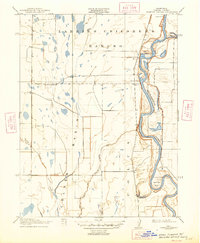
1917 Map of Compton Landing
USGS Topo · Published 1917About this map
The Sacramento River meanders through this portion of Colusa County, defined by its complex bends and the expansive lowlands of the Colusa Basin. At the time of this 1904 survey, the river served as a primary artery for movement, anchored by riverside points like Compton Landing and Boggs Landing. Much of the northern terrain is occupied by the Larkins Childrens Rancho, reflecting the legacy of Spanish and Mexican land grants in the Central Valley. Irrigation infrastructure and natural drainage are central to the landscape, with features such as Stone Corral Creek, Cheney Slough, and the dramatic Hamilton Bend illustrating the hydraulic complexity of the region. This map records a specific moment in the reclamation and agricultural development of the valley floor before modern levee systems fully transformed the natural floodplains.
Find a feature on this map
11 named features on this map. Tap any name to fly to it.
Don’t see what you’re looking for? This feature index may not catch every label — zoom into the map to look around manually.
Map Details
Editions of this 1917 Compton Landing Map
2 editions found
Other maps of this area

1888 · Marysville
USGS Topo · 1:125,000

1891 · Marysville
USGS Topo · 1:125,000

1894 · Marysville
USGS Topo · 1:125,000

1895 · Marysville
USGS Topo · 1:125,000

1906 · Maxwell
USGS Topo · 1:62,500

1907 · Colusa
USGS Topo · 1:62,500

1911 · Sanborn Slough
USGS Topo · 1:31,680

1912 · Butte City
USGS Topo · 1:31,680

1912 · Meridian
USGS Topo · 1:31,680

1917 · Logandale
USGS Topo · 1:31,680