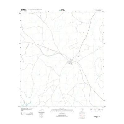
2013 Map of Comstock
USGS Topo · Published 2013About this map
Comstock serves as a central hub in this arid landscape of Val Verde County, where local streets like Del Rio St and School St form the small community core. The surrounding terrain is defined by the deep incisions of Cow Cr and Evans Cr, which snake across the plateau toward the waters of the Amistad Reservoir in the southwest corner. This map documents a transition point between ranching life and recreational space, with the Amistad Natl Rec Area protecting the shoreline while private airstrips like the Robertson Ranch Airport and long stretches of Ranch Road 1024 and Zubenbueler Ranch Rd maintain connections across the wide, limestone-carved plains.
Find a feature on this map
13 named features on this map. Tap any name to fly to it.
Don’t see what you’re looking for? This feature index may not catch every label — zoom into the map to look around manually.
Map Details
Editions of this 2013 Comstock Map
This is the sole edition of this map. No revisions or reprints were ever made.
Other maps of this area

1941 · Feely
USGS Topo · 1:62,500

1943 · Shumla
USGS Topo · 1:62,500

1944 · Mouth Of Pecos
USGS Topo · 1:62,500

1944 · Baker Crossing
USGS Topo · 1:62,500

1958 · Del Rio
USGS Topo · 1:250,000

1964 · Del Rio
USGS Topo · 1:250,000

1972 · California Creek
USGS Topo · 1:24,000

1972 · Seminole Canyon
USGS Topo · 1:24,000
1972 · Zuberbueler Bend
USGS Topo · 1:24,000
1972 · Box Canyon
USGS Topo · 1:24,000