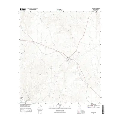
2016 Map of Comstock
USGS Topo · Published 2016About this map
Comstock serves as the primary hub in this arid landscape, where the intersection of Old Hwy 90 and Ranch Rd 1024 anchors the local transportation network. To the south, the terrain transitions into the managed lands of the Amistad National Recreation Area, characterized by deeply incised drainages like Rough Canyon and Chapote Draw. These geographic features illustrate the complex drainage patterns leading toward the Rio Grande basin, including the ephemeral flows of Cow Cr and Evans Cr. The presence of the Robertson Ranch Airport northeast of the settlement highlights the importance of private aviation in managing these expansive ranching properties. Local streets such as Sanderson St and Alpine St define the residential core of the community, while outlying routes like Zubenbueler Ranch Rd provide access to the remote backcountry of Val Verde County.
Find a feature on this map
15 named features on this map. Tap any name to fly to it.
Don’t see what you’re looking for? This feature index may not catch every label — zoom into the map to look around manually.
Map Details
Editions of this 2016 Comstock Map
This is the sole edition of this map. No revisions or reprints were ever made.
Other maps of this area

1941 · Feely
USGS Topo · 1:62,500

1943 · Shumla
USGS Topo · 1:62,500

1944 · Mouth Of Pecos
USGS Topo · 1:62,500

1944 · Baker Crossing
USGS Topo · 1:62,500

1958 · Del Rio
USGS Topo · 1:250,000

1964 · Del Rio
USGS Topo · 1:250,000

1972 · California Creek
USGS Topo · 1:24,000

1972 · Seminole Canyon
USGS Topo · 1:24,000
1972 · Zuberbueler Bend
USGS Topo · 1:24,000
1972 · Box Canyon
USGS Topo · 1:24,000