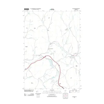
2012 Map of Concord
USGS Topo · Published 2012About this map
Moose River dominates the central valley of this Northeast Kingdom landscape, carving a path through East Saint Johnsbury toward Concord. The terrain is defined by high points like Saddleback Mountain, Mount Pisgah, and Sugar Hill, while the local history is preserved in a dense network of family and community burial grounds including South Kirby Cem, Cushman Cem, and Adams Babcock Cem. Settlement patterns follow the river and the many mountain brooks, such as Ranney Brook and Simpson Brook, that drain the surrounding hills. This survey documents the modern layout of rural roads and infrastructure, including the Moose River Campground and Rustic Haven Campground, highlighting the area's contemporary role as a gateway to the mountains. Genealogists will find particular value in the identified cemeteries near Stiles Pond, such as Stiles Cem and the Hill Cem located just west of the main settlement.
Find a feature on this map
94 named features on this map. Tap any name to fly to it.
Don’t see what you’re looking for? This feature index may not catch every label — zoom into the map to look around manually.
Map Details
Editions of this 2012 Concord Map
This is the sole edition of this map. No revisions or reprints were ever made.
Other maps of this area

1931 · Littleton
USGS Topo · 1:62,500

1932 · Littleton
USGS Topo · 1:48,000

1935 · Littleton
USGS Topo · 1:62,500

1935 · Lyndonville
USGS Topo · 1:48,000

1938 · St. Johnsbury
USGS Topo · 1:48,000

1939 · Lyndonville
USGS Topo · 1:62,500

1943 · St. Johnsbury
USGS Topo · 1:62,500
1949 · St. Johnsbury
USGS Topo · 1:62,500

1950 · Lake Champlain
USGS Topo · 1:250,000

1950 · Lewiston
USGS Topo · 1:250,000