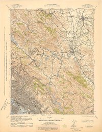
1943 Map of Concord
USGS Topo · Published 1943About this map
St Marys College and the surrounding Moraga Valley anchor the southern portion of this mid-century survey, conducted during a period of rapid development in the East Bay. The landscape transitions from the urban density of Oakland and Berkeley along the San Francisco Bay into the interior valleys of Contra Costa County. Strategic infrastructure like the San Pablo Reservoir and the Upper San Leandro Reservoir underscores the importance of water management for the growing population centers.
Find a feature on this map
89 named features on this map. Tap any name to fly to it.
Don’t see what you’re looking for? This feature index may not catch every label — zoom into the map to look around manually.
Map Details
Editions of this 1943 Concord Map
This is the sole edition of this map. No revisions or reprints were ever made.
Other maps of this area

1892 · San Mateo
USGS Topo · 1:62,500

1895 · San Francisco
USGS Topo · 1:62,500

1896 · San Mateo
USGS Topo · 1:62,500

1896 · Carquinez Strait
USGS Topo · 1:62,500

1896 · Mt. Diablo
USGS Topo · 1:62,500

1897 · Concord
USGS Topo · 1:62,500

1898 · Karquines
USGS Topo · 1:62,500

1898 · Mt. Diablo
USGS Topo · 1:62,500

1899 · San Francisco
USGS Topo · 1:62,500

1899 · Haywards
USGS Topo · 1:62,500