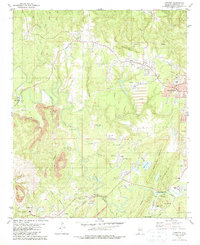
1979 Map of Concord
USGS Topo · Published 1987About this map
Industrial extraction and rural community life intersect in this 1970s study of Jefferson County. The landscape is defined by the massive footprint of the Concord Mine, where a sprawling complex of tailings, conveyors, and industrial waste ponds sits adjacent to the growing residential blocks of Hueytown. Despite the heavy industry, traditional landmarks like Rock Creek Cem and Earnest Ch remain as anchors for local genealogy. To the south, the terrain becomes increasingly complex as the Louisville and Nashville Railroad snakes along the banks of Valley Creek, serving a series of strip mines and the Blue Creek No 3 Mine near Adger. This survey provides a precise record of the infrastructure supporting Alabama's coal economy, from the Coal Silo near Lick Creek to the network of air shafts and pipelines cutting through the ridges of West Rock Mountain.
Find a feature on this map
56 named features on this map. Tap any name to fly to it.
Don’t see what you’re looking for? This feature index may not catch every label — zoom into the map to look around manually.
Map Details
Editions of this 1979 Concord Map
2 editions found
Other maps of this area

1889 · Birmingham
USGS Topo · 1:125,000

1890 · Bessemer
USGS Topo · 1:125,000

1892 · Birmingham
USGS Topo · 1:125,000

1892 · Bessemer
USGS Topo · 1:125,000

1893 · Jasper
USGS Topo · 1:125,000

1895 · Birmingham
USGS Topo · 1:125,000

1899 · Brookwood
USGS Topo · 1:125,000

1904 · Birmingham Coal District
USGS Topo · 1:62,500

1905 · Bessemer Iron District
USGS Topo · 1:62,500

1906 · Birmingham Special
USGS Topo · 1:62,500