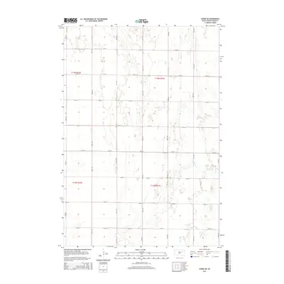
2015 Map of Conde SW
USGS Topo · Published 2015About this map
Timber Cr meanders through the eastern portion of this Spink County landscape, defining the drainage patterns of a region dominated by the rigid grid of the Public Land Survey System. The map shows the intersection of four townships, including t119n r62w, t119n r61w, t118n r62w, and t118n r61w, reflecting the systematic agricultural partitioning of the South Dakota prairie. A network of rural section-line roads, such as 399th Ave and 157th St, provides access across the open terrain, where small depressions and ephemeral water bodies dot the high plains between 400th Ave and 405th Ave. This digital-era survey provides a precise look at the land's contours and hydrologic features, including the various branches of Timber Creek as they flow southward toward the edge of the quadrangle.
Find a feature on this map
20 named features on this map. Tap any name to fly to it.
Don’t see what you’re looking for? This feature index may not catch every label — zoom into the map to look around manually.
Map Details
Editions of this 2015 Conde SW Map
This is the sole edition of this map. No revisions or reprints were ever made.
Other maps of this area

1894 · Conde
USGS Topo · 1:62,500

1895 · Byron
USGS Topo · 1:125,000

1895 · Aberdeen
USGS Topo · 1:125,000

1953 · Brentford
USGS Topo · 1:24,000

1953 · Frankfort
USGS Topo · 1:24,000

1953 · Huron
USGS Topo · 1:250,000

1954 · Aberdeen
USGS Topo · 1:250,000

1954 · Huron
USGS Topo · 1:250,000

1956 · Aberdeen
USGS Topo · 1:250,000
1958 · Randolph
USGS Topo · 1:24,000