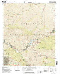
1995 Map of Condor Peak
USGS Topo · Published 1999About this map
Angeles National Forest dominates this mid-1990s landscape, where the steep canyons of the San Gabriel Mountains meet the developing fringes of the northern Los Angeles basin. The hydrology of the region is centered on the Big Tujunga Creek and its major impoundment at the Big Tujunga Dam, which creates the Big Tujunga Reservoir. This infrastructure serves as a critical focal point between high summits like Condor Peak and Mount Lukens.
Find a feature on this map
55 named features on this map. Tap any name to fly to it.
Don’t see what you’re looking for? This feature index may not catch every label — zoom into the map to look around manually.
Map Details
Editions of this 1995 Condor Peak Map
This is the sole edition of this map. No revisions or reprints were ever made.
Other maps of this area

1894 · Los Angeles
USGS Topo · 1:62,500

1896 · Pasadena
USGS Topo · 1:62,500

1896 · Santa Monica
USGS Topo · 1:62,500

1898 · Santa Monica
USGS Topo · 1:62,500

1900 · Pasadena
USGS Topo · 1:62,500

1900 · Tujunga
USGS Topo · 1:62,500

1900 · Los Angeles
USGS Topo · 1:62,500

1900 · Fernando
USGS Topo · 1:62,500

1901 · Southern California Sheet No. 1
USGS Topo · 1:250,000

1902 · Santa Monica
USGS Topo · 1:62,500