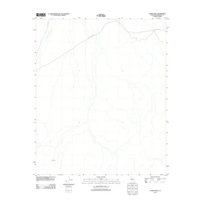
2012 Map of Conejo Well
USGS Topo · Published 2012About this map
Conejo Well provides a central reference point in this arid Riverside County landscape, where water sources and desert transit routes dictated movement through the terrain. The map detail highlights the significance of ephemeral drainage systems like Smoke Tree Wash, which crisscross the valley floor and shape the alluvial fans. Infrastructure in this area is defined by two primary corridors: Mecca Dale Rd and Black Eagle Mine Rd, which converge in the northern portion of the quadrangle. These roads indicate a history of industrial access, likely serving the mining operations implied by the namesake route. The 2012 survey illustrates a region where sparse named features underscore the isolation of the high desert, centered around essential water stops and the tracks carved by early prospecting and resource extraction.
Find a feature on this map
4 named features on this map. Tap any name to fly to it.
Don’t see what you’re looking for? This feature index may not catch every label — zoom into the map to look around manually.
Map Details
Editions of this 2012 Conejo Well Map
This is the sole edition of this map. No revisions or reprints were ever made.
Other maps of this area

1940 · Cottonwood Spring
USGS Topo · 1:62,500

1940 · Canyon Spring
USGS Topo · 1:62,500

1943 · Canyon Spring
USGS Topo · 1:62,500

1943 · Pinkham Well
USGS Topo · 1:62,500

1944 · Cottonwood Spring
USGS Topo · 1:62,500

1944 · Pinkham Well
USGS Topo · 1:62,500

1944 · Eagle Tank
USGS Topo · 1:62,500

1954 · Salton Sea
USGS Topo · 1:250,000

1955 · Salton Sea
USGS Topo · 1:250,000
1958 · Cottonwood Spring
USGS Topo · 1:62,500