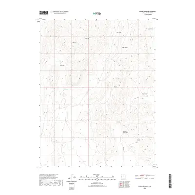
2020 Map of Conger Mountain
USGS Topo · Published 2020About this map
Conger Mtn serves as the dominant landmark of this arid Millard County landscape, situated within the wider Confusion Range. The area is defined by a series of deep drainage systems and canyons, including Camp Canyon, Ledger Canyon, and the curiously named Little Mile and a Half Canyon. This 2020 survey reveals a topography heavily utilized by the livestock industry, as evidenced by names such as Cattlemens Little Valley and Sheepmens Little Valley. Water remains the most critical resource here, with Conger Spring and Browns Wash providing essential points of relief in an otherwise parched environment. Transportation through the rugged terrain is limited to primitive routes like Mile and a Half Rd, which navigates the draws and flats between Dowdell Canyon and the surrounding peaks.
Find a feature on this map
15 named features on this map. Tap any name to fly to it.
Don’t see what you’re looking for? This feature index may not catch every label — zoom into the map to look around manually.
Map Details
Editions of this 2020 Conger Mountain Map
This is the sole edition of this map. No revisions or reprints were ever made.
Other maps of this area

1908 · Fish Springs
USGS Topo · 1:250,000

1910 · Fish Springs
USGS Topo · 1:250,000

1953 · Delta
USGS Topo · 1:250,000

1958 · Delta
USGS Topo · 1:250,000

1959 · Cowboy Pass
USGS Topo · 1:62,500

1960 · Conger Range
USGS Topo · 1:62,500

1960 · Gandy
USGS Topo · 1:62,500

1960 · Conger Mountain
USGS Topo · 1:62,500

1962 · Delta
USGS Topo · 1:250,000
1981 · Tule Valley
USGS Topo · 1:100,000