
1960 Map of Conger Mountain
USGS Topo · Published 1962About this map
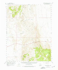
Conger Mountain dominates the northwestern landscape of this Great Basin survey, where the massive north-south spine of the Confusion Range separates two distinct basins. To the east lies the broad expanse of the Tule Valley, while the west is defined by the Little Valley and the arid flats of the Ferguson Desert. The map reveals a land structured by water scarcity and grazing geography, centered on vital points like Conger Spring and Conger Reservoir. The intricate network of drainage is visible through features like Little Mile and a Half Canyon and Payson Canyon, which cut through the limestone ridges. Evidence of mid-century range management and travel is found in the scattered Jeep Trails and specific grazing landmarks such as Sheepmens Little Valley and Horse Heaven.
Find a feature on this map
28 named features on this map. Tap any name to fly to it.
Don’t see what you’re looking for? This feature index may not catch every label — zoom into the map to look around manually.
Map Details
Editions of this 1960 Conger Mountain Map
2 editions found
Other maps of this area

1908 · Fish Springs
USGS Topo · 1:250,000

1910 · Fish Springs
USGS Topo · 1:250,000

1953 · Richfield
USGS Topo · 1:250,000

1953 · Delta
USGS Topo · 1:250,000

1958 · Richfield
USGS Topo · 1:250,000

1958 · Delta
USGS Topo · 1:250,000

1959 · Cowboy Pass
USGS Topo · 1:62,500

1960 · Notch Peak
USGS Topo · 1:62,500

1960 · Conger Range
USGS Topo · 1:62,500

1960 · Burbank Hills
USGS Topo · 1:62,500