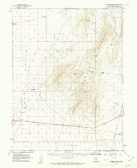
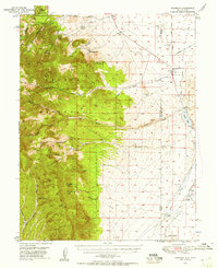
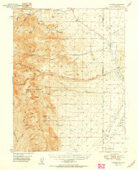
1960 Map of Conger Range
USGS Topo · Published 1962About this map
Conger Range and the surrounding high desert of Millard County are documented here following aerial surveys in the 1950s and ground-level work in 1960. This arid landscape is defined by the migration of water and movement through mountain gaps. Small outposts like Robison Ranch and the religious community at Eskdale highlight the sparse settlement patterns required by the environment. The map details a complex system of livestock-supporting features, including Knoll Springs and the Little Valley Well, which were essential for maintaining cattle across the Ferguson Desert. Numerous passes through the limestone peaks, such as Okelberry Pass, Coyote Pass, and Toms Knoll Pass, show the established routes used by ranchers and surveyors to navigate the terrain. Geographic landmarks like the Buckskin Hills and the curiously named Hole in the Ground provide distinct navigational points in an otherwise expansive wilderness.
Find a feature on this map
26 named features on this map. Tap any name to fly to it.
Don’t see what you’re looking for? This feature index may not catch every label — zoom into the map to look around manually.
Map Details
Editions of this 1960 Conger Range Map
This is the sole edition of this map. No revisions or reprints were ever made.
Other maps of this area

1908 · Fish Springs
USGS Topo · 1:250,000

1910 · Fish Springs
USGS Topo · 1:250,000
1949 · Garrison
USGS Topo · 1:62,500
1951 · Garrison
USGS Topo · 1:62,500

1953 · Richfield
USGS Topo · 1:250,000

1953 · Delta
USGS Topo · 1:250,000

1956 · Lund
USGS Topo · 1:250,000

1956 · Ely
USGS Topo · 1:250,000

1958 · Richfield
USGS Topo · 1:250,000

1958 · Delta
USGS Topo · 1:250,000