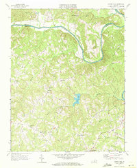
1968 Map of Conner Lake
USGS Topo · Published 1972About this map
The Roanoke River defines the northern and eastern reaches of this rural landscape on the border of Charlotte and Halifax counties. Small agricultural communities and crossroads hubs anchor the countryside, including the namesake Conner Lake and the settlement of Providence. The map reveals a dense network of country congregations, such as Staunton River Ch, Mount Pleasant Ch, and Bethel Grove Ch, which suggest the deep-rooted social fabric of this tobacco-growing region in the late 1960s.
Find a feature on this map
26 named features on this map. Tap any name to fly to it.
Don’t see what you’re looking for? This feature index may not catch every label — zoom into the map to look around manually.
Map Details
Editions of this 1968 Conner Lake Map
2 editions found
Other maps of this area

1892 · Appomattox
USGS Topo · 1:125,000

1947 · Roanoke
USGS Topo · 1:250,000

1953 · Greensboro
USGS Topo · 1:250,000

1954 · Greensboro
USGS Topo · 1:250,000

1954 · Clover
USGS Topo · 1:62,500

1954 · Halifax
USGS Topo · 1:62,500

1956 · Brookneal
USGS Topo · 1:62,500

1956 · Charlotte Court House
USGS Topo · 1:62,500

1959 · Roanoke
USGS Topo · 1:250,000

1962 · Greensboro
USGS Topo · 1:250,000