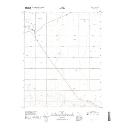
2018 Map of Conrad NW
USGS Topo · Published 2018About this map
Boise City anchors the northwestern corner of this landscape, serving as a hub for the high plains of the Oklahoma Panhandle. The terrain is defined by the canyon-like drainage of the Beaver River, which winds across the southern reaches of the map through Township t2n r6e and t2n r5e. This river system represents a vital water source in an otherwise arid region dominated by a precise grid of section-line roads, such as e0190 RD and e0200 RD, that facilitate the area's agricultural and ranching operations. For local historians and genealogists, the map preserves the location of the Garlington Cem, a small burial ground situated east of the primary north-south transit corridor. The map illustrates how transportation routes like U.S. Route 287 cut diagonally across the survey squares, connecting the isolated seat of Cimarron County to the broader plains.
Find a feature on this map
21 named features on this map. Tap any name to fly to it.
Don’t see what you’re looking for? This feature index may not catch every label — zoom into the map to look around manually.
Map Details
Editions of this 2018 Conrad NW Map
This is the sole edition of this map. No revisions or reprints were ever made.
Other maps of this area

1954 · Dalhart
USGS Topo · 1:250,000

1958 · Dalhart
USGS Topo · 1:250,000

1962 · Dalhart
USGS Topo · 1:250,000

1969 · Boise City
USGS Topo · 1:24,000

1969 · Flagg Springs
USGS Topo · 1:24,000

1969 · Boise City SE
USGS Topo · 1:24,000

1971 · Keyes SW
USGS Topo · 1:24,000

1971 · Keyes West
USGS Topo · 1:24,000

1971 · Sampsel Lake
USGS Topo · 1:24,000

1971 · Conrad NW
USGS Topo · 1:24,000