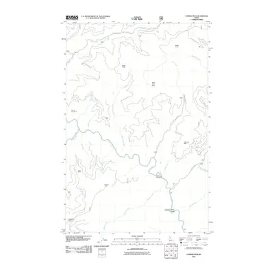
2011 Map of Conrad Peak
USGS Topo · Published 2011About this map
The Saint Joe River carves a winding path through this corner of Shoshone County, serving as the central drainage for a landscape defined by sharp ridges and deep creek basins. The map identifies the Saint Joe Quartz Mine on the western slopes, a site that speaks to the region's mineral prospecting history. This 2011 survey documents a network of Forest Service roads, including Quartz Creek Rd and Bruin Creek Rd, which provide access to high points like Black Jack Peak and Whitetail Peak. Recreational use is anchored by river-adjacent sites such as the Conrad Crossing Campground and Gold Creek Campground. Numerous drainages like Tumbledown Creek and Aconite Creek feed into the main river, illustrating the complex hydrology of the Bitterroot mountains.
Find a feature on this map
38 named features on this map. Tap any name to fly to it.
Don’t see what you’re looking for? This feature index may not catch every label — zoom into the map to look around manually.
Map Details
Editions of this 2011 Conrad Peak Map
This is the sole edition of this map. No revisions or reprints were ever made.
Other maps of this area

1914 · Avery
USGS Topo · 1:125,000

1917 · Avery
USGS Topo · 1:125,000

1918 · St Regis
USGS Topo · 1:125,000

1919 · St. Regis
USGS Topo · 1:125,000

1956 · Saltese
USGS Topo · 1:62,500

1956 · Wallace
USGS Topo · 1:250,000

1957 · Haugan
USGS Topo · 1:62,500

1957 · Simmons Peak
USGS Topo · 1:62,500

1960 · Wallace
USGS Topo · 1:250,000
1969 · Bathtub Mtn
USGS Topo · 1:24,000