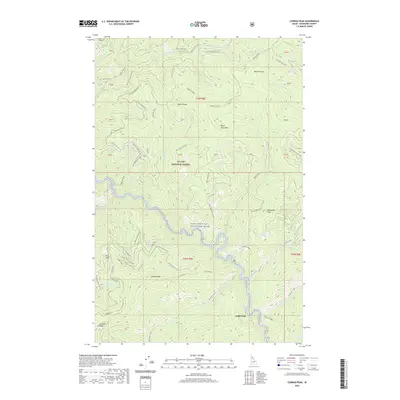
2020 Map of Conrad Peak
USGS Topo · Published 2020About this map
The Saint Joe Wild and Scenic River carves a deep, sinuous path through the heart of the St. Joe National Forest, serving as the primary hydrological artery for this mountain landscape. High peaks such as Conrad Peak, Whitetail Peak, and Black Jack Peak define the horizon, while an intricate network of off-highway vehicle (OHV) trails like Saddle Ohv and Black Jack Ohv navigate the steep ridgelines. The concentration of OHV routes, including the Quartz-Haggerty Ohv and Lower Lookout Ohv, reflects the modern recreational use of these historical forest corridors. Along the slopes, features like Bear Spring and numerous drainages including Mosquito Cr and Quartz Creek demonstrate the complex watershed feeding the Saint Joe. The map detail provides a clear view of the forest's topographic structure, from the heights of Beetle Hump to the deep cut of Gold Creek.
Find a feature on this map
71 named features on this map. Tap any name to fly to it.
Don’t see what you’re looking for? This feature index may not catch every label — zoom into the map to look around manually.
Map Details
Editions of this 2020 Conrad Peak Map
This is the sole edition of this map. No revisions or reprints were ever made.
Other maps of this area

1914 · Avery
USGS Topo · 1:125,000

1917 · Avery
USGS Topo · 1:125,000

1918 · St Regis
USGS Topo · 1:125,000

1919 · St. Regis
USGS Topo · 1:125,000

1956 · Saltese
USGS Topo · 1:62,500

1956 · Wallace
USGS Topo · 1:250,000

1957 · Haugan
USGS Topo · 1:62,500

1957 · Simmons Peak
USGS Topo · 1:62,500

1960 · Wallace
USGS Topo · 1:250,000
1969 · Bathtub Mtn
USGS Topo · 1:24,000