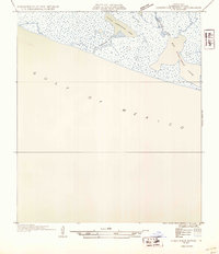
1954 Map of Constance Bayou SW
USGS Topo · Published 1954About this map
Gulf of Mexico coastal marshland dominates this 1954 survey of Cameron Parish, reflecting a landscape defined by tidewater and brackish lagoons. The intricate drainage patterns of Constance Bayou and Little Constance Bayou connect the interior wetlands to the open sea, illustrating the transition between the coastal prairie and the gulf. These water bodies, including the expansive Big Constance Lake and its smaller counterpart, Little Constance Lake, are critical features of this low-lying environment. Compiled from aerial photographs taken by the Air Corps, the map captures the primitive state of the Louisiana shoreline before extensive modern infrastructure altered the natural hydrological flow of the parish's chenier plain.
Find a feature on this map
5 named features on this map. Tap any name to fly to it.
Don’t see what you’re looking for? This feature index may not catch every label — zoom into the map to look around manually.
Map Details
Editions of this 1954 Constance Bayou SW Map
This is the sole edition of this map. No revisions or reprints were ever made.
Other maps of this area

1932 · Constance Bayou NE
USGS Topo · 1:31,680

1932 · Constance Bayou SW
USGS Topo · 1:31,680

1932 · Constance Bayou SE
USGS Topo · 1:31,680

1932 · Constance Bayou NW
USGS Topo · 1:31,680

1946 · Hog Bayou NE
USGS Topo · 1:31,680

1949 · Hog Bayou NE
USGS Topo · 1:31,680
1954 · Constance Bayou SE
USGS Topo · 1:31,680
1954 · Constance Bayou NW
USGS Topo · 1:31,680

1954 · Port Arthur
USGS Topo · 1:250,000
1955 · Constance Bayou
USGS Topo · 1:62,500