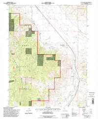
1994 Map of Constantia
USGS Topo · Published 1998About this map
Long Valley Creek and Dry Valley Creek carve a path through this high-altitude landscape on the edge of the Plumas National Forest. The map documents a sparsely populated region where the small settlements of Omira and Constantia sit near the base of the Fort Sage Mountains. In the western reaches, the topography rises sharply toward Adams Peak and the Eagles Peak Ski Area, reflecting the area's transition into more mountainous terrain. Evidence of local extraction and leisure is visible through several prospects, a quarry, and the Zamboni Hot Springs. The boundary between Lassen and Plumas counties runs through the center of the sheet, dividing these high-desert valleys and peaks during the mid-1990s.
Find a feature on this map
21 named features on this map. Tap any name to fly to it.
Don’t see what you’re looking for? This feature index may not catch every label — zoom into the map to look around manually.
Map Details
Editions of this 1994 Constantia Map
2 editions found
Other maps of this area

1886 · Honey Lake
USGS Topo · 1:250,000

1886 · Granite Range
USGS Topo · 1:250,000

1890 · Sierraville
USGS Topo · 1:125,000

1891 · Honey Lake
USGS Topo · 1:250,000

1891 · Reno
USGS Topo · 1:125,000

1892 · Sierraville
USGS Topo · 1:125,000

1893 · Honey Lake
USGS Topo · 1:250,000

1893 · Reno
USGS Topo · 1:125,000

1894 · Granite Range
USGS Topo · 1:250,000

1894 · Sierraville
USGS Topo · 1:125,000