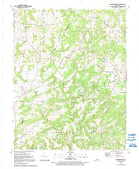
1991 Map of Constantine
USGS Topo · Published 1992About this map
Constantine and Vertrees serve as the primary hubs in this corner of Kentucky, where the landscape is defined by the winding course of the Rough River and its numerous tributaries. The mapping shows a deeply etched drainage pattern featuring Losenville Creek, Vertrees Creek, and Dry Bed Creek, carving out distinctive terrain like Losenville Valley and Laurel Ridge. The settlement pattern follows the ridge lines and valleys, connected by a network of rural roads such as Constantine Road and Grandview Road.
Find a feature on this map
56 named features on this map. Tap any name to fly to it.
Don’t see what you’re looking for? This feature index may not catch every label — zoom into the map to look around manually.
Map Details
Editions of this 1991 Constantine Map
This is the sole edition of this map. No revisions or reprints were ever made.
Other maps of this area

1928 · Hardinsburg
USGS Topo · 1:48,000

1931 · Hardinsburg
USGS Topo · 1:62,500

1932 · Big Clifty
USGS Topo · 1:62,500

1941 · Ekron
USGS Topo · 1:62,500

1947 · Garfield
USGS Topo · 1:24,000

1947 · Hardinsburg
USGS Topo · 1:62,500

1947 · Ekron
USGS Topo · 1:62,500
1948 · Flaherty
USGS Topo · 1:24,000
1948 · Big Spring
USGS Topo · 1:24,000

1949 · Constantine
USGS Topo · 1:24,000