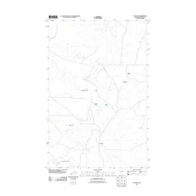
2011 Map of Content
USGS Topo · Published 2011About this map
The small settlement of Content sits at the intersection of a vast network of drainage channels in central Montana. This 2011 survey reveals an arid landscape defined by its hydrography and topography, where Spring Creek and Flat Creek meander through the southern reaches. The terrain is deeply incised by Numerous coulees, or dry canyons, which speak to the erosional patterns of the northern plains. Significant features include Smith Coulee, Twin Lake Coulee, and No Name Coulee, which carve through the land toward the main artery of Beaver Creek. To the southwest, the Sun Prairie Flats provide a more level expanse relative to the broken ground further north. Human impact on the hydrology is visible at Row Dam, a local landmark indicative of water management in this high-prairie environment. The map provides a clear picture of the ranching-ready landscape connected by Content Rd and various local thoroughfares.
Find a feature on this map
16 named features on this map. Tap any name to fly to it.
Don’t see what you’re looking for? This feature index may not catch every label — zoom into the map to look around manually.
Map Details
Editions of this 2011 Content Map
This is the sole edition of this map. No revisions or reprints were ever made.
Other maps of this area

1954 · Jordan
USGS Topo · 1:250,000

1954 · Glasgow
USGS Topo · 1:250,000

1956 · Jordan
USGS Topo · 1:250,000

1957 · Glasgow
USGS Topo · 1:250,000

1958 · Glasgow
USGS Topo · 1:250,000

1958 · Jordan
USGS Topo · 1:250,000

1964 · Jordan
USGS Topo · 1:250,000

1965 · Buckley Lake
USGS Topo · 1:24,000

1965 · Sheep Coulee
USGS Topo · 1:24,000
1973 · White Horse Coulee
USGS Topo · 1:24,000