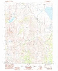
1983 Map of Convict Lake
USGS Topo · Published 1984About this map
The high Sierra peaks of Mt Morrison and Mt Baldwin dominate this 1980s landscape, where high-altitude research and recreation converge. The Sierra Nevada Aquatic Research Laboratory is positioned at the northern edge of the map, while the deep waters of Convict Lake and its corresponding Convict Lake Campground represent the area's developed outdoor corridor. The presence of the Scheelore Mine and Hilton Creek Mine indicates the region's history of mineral extraction within these steep glaciated valleys.
Find a feature on this map
38 named features on this map. Tap any name to fly to it.
Don’t see what you’re looking for? This feature index may not catch every label — zoom into the map to look around manually.
Map Details
Editions of this 1983 Convict Lake Map
This is the sole edition of this map. No revisions or reprints were ever made.
Other maps of this area

1912 · Mt. Goddard
USGS Topo · 1:125,000

1914 · Mt. Morrison
USGS Topo · 1:125,000

1947 · Mariposa
USGS Topo · 1:250,000

1948 · Mariposa
USGS Topo · 1:250,000

1949 · Mt. Tom
USGS Topo · 1:62,500

1951 · Mt. Tom
USGS Topo · 1:62,500

1953 · Mt. Morrison
USGS Topo · 1:62,500

1953 · Casa Diablo Mtn
USGS Topo · 1:62,500

1953 · Mt Abbot
USGS Topo · 1:62,500
1954 · Mt. Tom
USGS Topo · 1:62,500