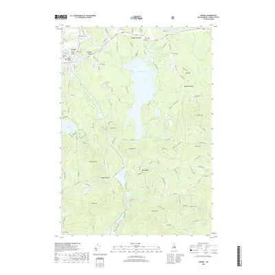
2018 Map of Conway
USGS Topo · Published 2018About this map
Conway Lake serves as the central geographic focal point for this Carroll County landscape, surrounded by a network of upland peaks and valley settlements. The village of Conway and neighboring Center Conway are situated near the confluence of the Swift River and the Saco River, where iconic landmarks like the Saco River Covered Bridge and Swift River Bridge reflect the area's long-standing transportation infrastructure. To the south, the terrain rises into the granite hills of the Mount Washington Valley, featuring distinctive summits such as Rockhouse Mtn, Atkinson Mtn, and Foss Mtn. Smaller hamlets like Snowville and Eaton Center are tucked between numerous glacial ponds, including Hatch Pond and Long Pond. This map preserves the locations of local landmarks such as Conway Village Cem and Potter Cem, which are significant for genealogists and local historians tracing the families who settled this corner of New Hampshire.
Find a feature on this map
120 named features on this map. Tap any name to fly to it.
Don’t see what you’re looking for? This feature index may not catch every label — zoom into the map to look around manually.
Map Details
Editions of this 2018 Conway Map
This is the sole edition of this map. No revisions or reprints were ever made.
Other maps of this area

1894 · North Conway
USGS Topo · 1:62,500

1896 · North Conway
USGS Topo · 1:62,500

1909 · Fryeburg
USGS Topo · 1:62,500

1910 · Kezar Falls
USGS Topo · 1:48,000

1911 · Fryeburg
USGS Topo · 1:62,500

1911 · Kezar Falls
USGS Topo · 1:62,500

1930 · Ossipee Lake
USGS Topo · 1:62,500

1941 · Fryeburg
USGS Topo · 1:62,500

1942 · North Conway
USGS Topo · 1:62,500

1945 · North Conway
USGS Topo · 1:62,500