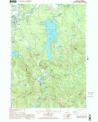
1998 Map of Conway
USGS Topo · Published 2001About this map
Conway Lake dominates the central landscape of this Carroll County survey, acting as a focal point for the surrounding village clusters. The settlement pattern reflects the area's transition from river-based industry at Conway and Center Conway to the agricultural and recreational highlands further south. Along the northern edge, the confluence of the Swift River and the Saco River highlights a traditional transportation corridor near the White Mountain National Forest.
Find a feature on this map
43 named features on this map. Tap any name to fly to it.
Don’t see what you’re looking for? This feature index may not catch every label — zoom into the map to look around manually.
Map Details
Editions of this 1998 Conway Map
This is the sole edition of this map. No revisions or reprints were ever made.
Other maps of this area

1894 · North Conway
USGS Topo · 1:62,500

1896 · North Conway
USGS Topo · 1:62,500

1909 · Fryeburg
USGS Topo · 1:62,500

1910 · Kezar Falls
USGS Topo · 1:48,000

1911 · Fryeburg
USGS Topo · 1:62,500

1911 · Kezar Falls
USGS Topo · 1:62,500

1930 · Ossipee Lake
USGS Topo · 1:62,500

1941 · Fryeburg
USGS Topo · 1:62,500

1942 · North Conway
USGS Topo · 1:62,500

1945 · North Conway
USGS Topo · 1:62,500