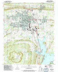
1994 Map of Conway
USGS Topo · Published 1994About this map
Conway serves as a vibrant educational and transportation hub in central Arkansas, defined by the campuses of Hendrix College, Central Baptist College, and the University of Central Arkansas. The city's grid is bisected by the Union Pacific railroad, reflecting a legacy of rail-oriented growth that connects northern neighborhoods near Cadron Ridge to the industrial and commercial corridors in the south. The landscape shifts dramatically south of the city center, where the high relief of Round Mountain overlooks the sprawling waters of Lake Conway. This transition from an academic and urban center to a riparian environment is marked by numerous boat access points such as Gold Creek Landing and Breams Nest Landing, emphasizing the importance of the lake for local recreation and the regional ecosystem. Smaller outlying communities like Brumley and Preston anchor the rural fringes, while the presence of the Camp Robinson State Wildlife Management Area at the southern border preserves the natural character of the Arkansas River valley.
Find a feature on this map
70 named features on this map. Tap any name to fly to it.
Don’t see what you’re looking for? This feature index may not catch every label — zoom into the map to look around manually.
Map Details
Editions of this 1994 Conway Map
This is the sole edition of this map. No revisions or reprints were ever made.
Other maps of this area

1890 · Benton
USGS Topo · 1:125,000

1891 · Little Rock
USGS Topo · 1:125,000

1892 · Morrillton
USGS Topo · 1:125,000

1893 · Little Rock
USGS Topo · 1:125,000

1894 · Morrillton
USGS Topo · 1:125,000

1894 · Benton
USGS Topo · 1:125,000

1953 · Cato
USGS Topo · 1:24,000

1953 · Mayflower
USGS Topo · 1:24,000

1955 · Little Rock
USGS Topo · 1:250,000

1956 · Little Rock
USGS Topo · 1:250,000