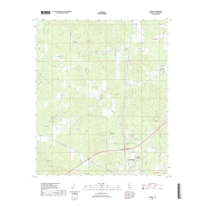
2018 Map of Conway
USGS Topo · Published 2018About this map
The northern edge of Carthage anchor this survey of central Mississippi, showing a landscape defined by small rural hubs and a network of named creek drainages. Significant water bodies like Pellaphalia Cr and Shala Cr wind through the terrain, with the Government Hills rising in the southwestern quadrant. The map records several small settlements including Conway and Redwater, connected by a web of local routes such as Harristown Rd and Cliff Roten Rd.
Find a feature on this map
87 named features on this map. Tap any name to fly to it.
Don’t see what you’re looking for? This feature index may not catch every label — zoom into the map to look around manually.
Map Details
Editions of this 2018 Conway Map
This is the sole edition of this map. No revisions or reprints were ever made.
Other maps of this area

1953 · Meridian
USGS Topo · 1:250,000

1957 · Meridian
USGS Topo · 1:250,000

1961 · Carthage
USGS Topo · 1:62,500

1962 · Edinburg
USGS Topo · 1:62,500

1962 · Thomastown
USGS Topo · 1:62,500

1965 · Meridian
USGS Topo · 1:250,000

1972 · McAfee
USGS Topo · 1:24,000

1984 · Carthage
USGS Topo · 1:100,000
1988 · Thomastown
USGS Topo · 1:24,000
1989 · Ofahoma
USGS Topo · 1:24,000