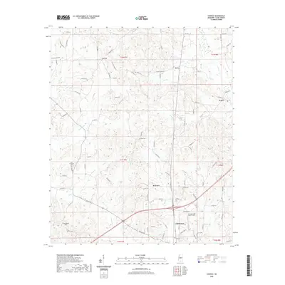
2020 Map of Conway
USGS Topo · Published 2020About this map
The city of Carthage anchors the southeastern corner of this Leake County survey, where modern development meets the rural landscapes of central Mississippi. North of the city, the terrain is defined by a dense network of tributaries including Pellaphalia Cr, Shiloa Cr, and Pickins Cr, which drain the varied topography near Government Hills. Small communities like Conway, Redwater, and Hopoca serve as local hubs, connected by a web of local roads such as Pleasant Grove Rd and Red Dog Rd. Genealogy researchers will find several well-preserved church yards and burial sites throughout the quadrangle, including Mount Zion Cem, Zion Hill Cem, and Scott Cem. The presence of the Carthage-Leake County Airport south of Redwater indicates the region's infrastructure as of 2020.
Find a feature on this map
90 named features on this map. Tap any name to fly to it.
Don’t see what you’re looking for? This feature index may not catch every label — zoom into the map to look around manually.
Map Details
Editions of this 2020 Conway Map
This is the sole edition of this map. No revisions or reprints were ever made.
Other maps of this area

1953 · Meridian
USGS Topo · 1:250,000

1957 · Meridian
USGS Topo · 1:250,000

1961 · Carthage
USGS Topo · 1:62,500

1962 · Edinburg
USGS Topo · 1:62,500

1962 · Thomastown
USGS Topo · 1:62,500

1965 · Meridian
USGS Topo · 1:250,000

1972 · McAfee
USGS Topo · 1:24,000

1984 · Carthage
USGS Topo · 1:100,000
1988 · Thomastown
USGS Topo · 1:24,000
1989 · Ofahoma
USGS Topo · 1:24,000