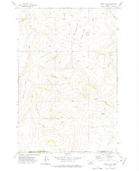
1971 Map of Conway Ridge
USGS Topo · Published 1975About this map
Conway Ridge and Streeter Hill define this high-altitude landscape along the border of Cascade and Meagher counties. In the early 1970s, the area remained a complex network of seasonal drainage and named springs, including the evocatively named Mowing Machine Coulee in the southern reaches. The terrain is deeply incised by the headwaters of several drainages, such as Hound Creek and Porcupine Creek, which converge among the high ridges.
Find a feature on this map
21 named features on this map. Tap any name to fly to it.
Don’t see what you’re looking for? This feature index may not catch every label — zoom into the map to look around manually.
Map Details
Editions of this 1971 Conway Ridge Map
This is the sole edition of this map. No revisions or reprints were ever made.
Other maps of this area

1886 · Great Falls
USGS Topo · 1:250,000

1886 · Fort Logan
USGS Topo · 1:250,000

1948 · White Sulphur Springs
USGS Topo · 1:250,000

1954 · Great Falls
USGS Topo · 1:250,000

1957 · Great Falls
USGS Topo · 1:250,000

1958 · White Sulphur Springs
USGS Topo · 1:250,000

1961 · White Sulphur Springs
USGS Topo · 1:250,000

1961 · Schrammeck Lake
USGS Topo · 1:24,000

1961 · Dana Ranch
USGS Topo · 1:24,000

1962 · B K Ranch
USGS Topo · 1:24,000