
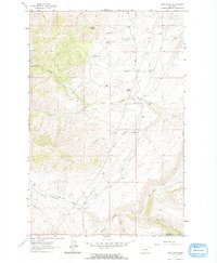
1961 Map of Dana Ranch
USGS Topo · Published 1964About this map
Large cattle operations and remote outposts define this stretch of the Cascade and Meagher County border in the early 1960s. The landscape is marked by established holdings such as the Dana Ranch and Staunton Ranch, alongside the noted location of Adel (Site), suggesting a shift from earlier settlement patterns to consolidated ranching. The terrain rises sharply toward The Pinnacles and Castle Rock, while water sources like Hound Creek and Fourteen Spring Creek carve through the draws. The reliance on primitive infrastructure is evident in the network of Jeep Trails and the singular Adel Road that connect isolated camps like Sheep Camp to the larger family-named ranches. This survey captures a moment before modern development altered the classic Montana ranching environment, preserving the names of specific family sites and seasonal camps across Wosinek Flats and Squaw Hollow.
Find a feature on this map
29 named features on this map. Tap any name to fly to it.
Don’t see what you’re looking for? This feature index may not catch every label — zoom into the map to look around manually.
Map Details
Editions of this 1961 Dana Ranch Map
2 editions found
Other maps of this area

1886 · Great Falls
USGS Topo · 1:250,000

1886 · Fort Logan
USGS Topo · 1:250,000

1948 · White Sulphur Springs
USGS Topo · 1:250,000

1954 · Great Falls
USGS Topo · 1:250,000

1957 · Great Falls
USGS Topo · 1:250,000

1958 · White Sulphur Springs
USGS Topo · 1:250,000

1961 · White Sulphur Springs
USGS Topo · 1:250,000

1961 · Hound Creek Reservoir
USGS Topo · 1:24,000

1961 · Rocky Reef
USGS Topo · 1:24,000

1961 · Schrammeck Lake
USGS Topo · 1:24,000