
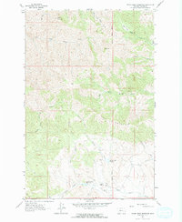
1961 Map of Hound Creek Reservoir
USGS Topo · Published 1964About this map
The Montana Principal Meridian bisects this high-country landscape in Cascade County, where the ranching operations of Sieben Ranch and Sieben define the local human footprint. The terrain is marked by dramatic elevation changes, characterized by The Pinnacles and Black Mountain, which overlook a complex network of waterways. Cattle and land management are evident through the presence of the Hound Creek Reservoir and Spring Creek Reservoir, essential water sources in this environment. The map details the drainage patterns of the West Fork Hound Creek and the South Fork Sheep Creek, which cut through the high plateaus and coulees. A primitive Jeep Trail provides the primary access through the eastern canyons, highlighting the area's isolation and reliance on traditional ranching infrastructure during the early 1960s.
Find a feature on this map
26 named features on this map. Tap any name to fly to it.
Don’t see what you’re looking for? This feature index may not catch every label — zoom into the map to look around manually.
Map Details
Editions of this 1961 Hound Creek Reservoir Map
2 editions found
Other maps of this area

1886 · Great Falls
USGS Topo · 1:250,000

1886 · Fort Logan
USGS Topo · 1:250,000

1948 · White Sulphur Springs
USGS Topo · 1:250,000

1954 · Great Falls
USGS Topo · 1:250,000

1957 · Great Falls
USGS Topo · 1:250,000

1958 · White Sulphur Springs
USGS Topo · 1:250,000

1961 · White Sulphur Springs
USGS Topo · 1:250,000

1961 · Hardy
USGS Topo · 1:24,000

1961 · Rocky Reef
USGS Topo · 1:24,000

1961 · Schrammeck Lake
USGS Topo · 1:24,000