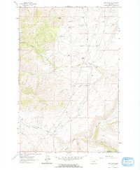
1961 Map of Dana Ranch
USGS Topo · Published 1964About this map
High ranching country along the Cascade and Meagher County line defines this landscape as it was surveyed in the early 1960s. The terrain is characterized by dramatic uplift and deep drainages, most notably seen in the craggy formations of The Pinnacles and the prominence of Castle Rock. The local economy of this era is etched into the map through its network of remote outposts, including the Dana Ranch, Gordon Ranch, and Thompson Ranch.
Find a feature on this map
29 named features on this map. Tap any name to fly to it.
Don’t see what you’re looking for? This feature index may not catch every label — zoom into the map to look around manually.
Map Details
Editions of this 1961 Dana Ranch Map
2 editions found

Other maps of this area

1886 · Great Falls
USGS Topo · 1:250,000

1886 · Fort Logan
USGS Topo · 1:250,000

1948 · White Sulphur Springs
USGS Topo · 1:250,000

1954 · Great Falls
USGS Topo · 1:250,000

1957 · Great Falls
USGS Topo · 1:250,000

1958 · White Sulphur Springs
USGS Topo · 1:250,000

1961 · White Sulphur Springs
USGS Topo · 1:250,000

1961 · Hound Creek Reservoir
USGS Topo · 1:24,000

1961 · Rocky Reef
USGS Topo · 1:24,000

1961 · Schrammeck Lake
USGS Topo · 1:24,000