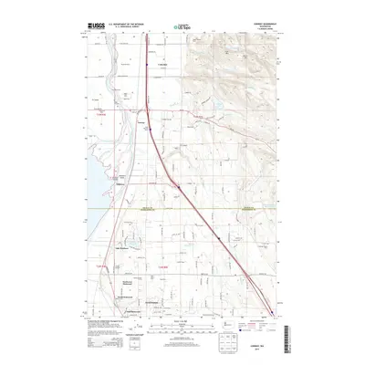
2014 Map of Conway
USGS Topo · Published 2014About this map
The agricultural delta where the South Fork Skagit River meets the complex waterways of Fir Island defines this region of Washington. Settlement clusters heavily along the transition from the fertile lowlands of Conway and Milltown to the rising elevations of Scott Mtn and Devils Mtn in the northeast. The landscape is a detailed map of early 21st-century rural industry, dotted with specific family and commercial operations like Westheim Farms, Smith Morrison Farms, and Folkertsma Dairy. In the south, the city of Stanwood is shown divided into its local districts, including North Stanwood, East Stanwood, and Northwest Stanwood. Beyond the urban core, the map reveals a network of water features such as Lake Ketchum and Sixteen Lake, alongside small airfields like JC's Airport and Sunset Airport, reflecting a mix of legacy farming and modern infrastructure.
Find a feature on this map
129 named features on this map. Tap any name to fly to it.
Don’t see what you’re looking for? This feature index may not catch every label — zoom into the map to look around manually.
Map Details
Editions of this 2014 Conway Map
This is the sole edition of this map. No revisions or reprints were ever made.
Other maps of this area

1911 · Mount Vernon
USGS Topo · 1:125,000

1940 · Mt Vernon
USGS Topo · 1:62,500

1941 · Marysville
USGS Topo · 1:62,500

1943 · Marysville
USGS Topo · 1:62,500

1943 · Mt Vernon
USGS Topo · 1:62,500

1943 · Stanwood
USGS Topo · 1:62,500

1944 · Clear Lake
USGS Topo · 1:62,500

1956 · Arlington West
USGS Topo · 1:24,000
1956 · Stanwood
USGS Topo · 1:24,000
1956 · Utsalady
USGS Topo · 1:24,000