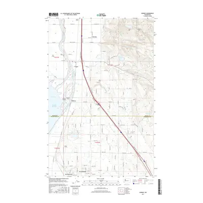
2017 Map of Conway
USGS Topo · Published 2017About this map
Stanwood and its surrounding delta lands are defined by the complex aquatic network of the South Fork Skagit River, where water moves through Steamboat Slough, Deepwater Slough, and Tom Moore Slough into Skagit Bay. This landscape reflects a century of reclamation and drainage, visible in the engineered lines of Hill Ditch and the preservation of Fir Island. On the eastern rise, the terrain transitions sharply to the wooded slopes of Scott Mtn and Devils Mtn, which overlook small upland bodies of water like Ten Lake and Sixteen Lake. The map details a transit-heavy corridor following Old Hwy 99, linking small agricultural and residential hubs such as Conway, Milltown, and Cedardale. For local historians, the inclusion of the Skagit City Cem and several private airfields like Sunset Airport and JC's Airport provides specific landmarks of 20th-century development across the Skagit and Snohomish county line.
Find a feature on this map
86 named features on this map. Tap any name to fly to it.
Don’t see what you’re looking for? This feature index may not catch every label — zoom into the map to look around manually.
Map Details
Editions of this 2017 Conway Map
This is the sole edition of this map. No revisions or reprints were ever made.
Other maps of this area

1911 · Mount Vernon
USGS Topo · 1:125,000

1940 · Mt Vernon
USGS Topo · 1:62,500

1941 · Marysville
USGS Topo · 1:62,500

1943 · Marysville
USGS Topo · 1:62,500

1943 · Mt Vernon
USGS Topo · 1:62,500

1943 · Stanwood
USGS Topo · 1:62,500

1944 · Clear Lake
USGS Topo · 1:62,500

1956 · Arlington West
USGS Topo · 1:24,000
1956 · Stanwood
USGS Topo · 1:24,000
1956 · Utsalady
USGS Topo · 1:24,000