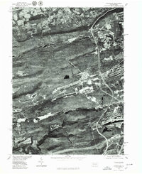
1976 Map of Conyngham
USGS Topo · Published 1979About this map
Conyngham sits in the valley below Sugarloaf Mountain in this mid-1970s orthophotoquad, which uses aerial photography from October 1976 to reveal the literal footprint of the Pennsylvania anthracite region. The imagery clearly distinguishes the residential grids of West Hazleton and Kelayres from the surrounding industrial and natural terrain. The geography is defined by parallel ridges including Buck Mountain and Little Sugarloaf Mountain, while Black Creek and Catawissa Creek drain the basins between them. For researchers, the photograph provides a raw view of the landscape before more recent development, documenting the exact extent of mining impacts and timber patterns near Harwood and Sheppton as they existed during the Bicentennial year.
Find a feature on this map
10 named features on this map. Tap any name to fly to it.
Don’t see what you’re looking for? This feature index may not catch every label — zoom into the map to look around manually.
Map Details
Editions of this 1976 Conyngham Map
This is the sole edition of this map. No revisions or reprints were ever made.
Other maps of this area

1889 · Hazleton
USGS Topo · 1:62,500

1891 · Wilkesbarre
USGS Topo · 1:62,500

1891 · Hazleton
USGS Topo · 1:62,500

1892 · Mahanoy
USGS Topo · 1:62,500

1893 · Hazleton
USGS Topo · 1:62,500

1893 · Mahanoy
USGS Topo · 1:62,500

1894 · Shickshinny
USGS Topo · 1:62,500

1894 · Wilkesbarre
USGS Topo · 1:62,500

1943 · Scranton
USGS Topo · 1:125,000

1944 · Newark
USGS Topo · 1:250,000
Featured Places
- Conyngham, PA
- Sheppton, East Union Township
- North Union Township, PA
- Black Creek Township, PA
- Hazle Township, PA