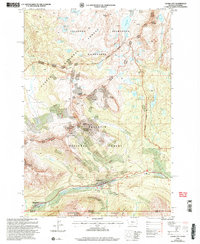
2000 Map of Cooke City
USGS Topo · Published 2005About this map
Cooke City sits at the heart of this high-elevation mountain terrain at the dawn of the millennium, surrounded by the overlapping boundaries of the Gallatin National Forest, Custer National Forest, and Shoshone National Forest. This mapping reflects a landscape shaped by historical mining and modern conservation, where high-country routes lead to numerous prospects and an open pit mine near Henderson Mountain. The rugged transition from the Absaroka - Beartooth Wilderness to the northern gate of Yellowstone is marked by landmarks like Cooke City Amphitheater and Soda Butte. Water systems define the geography, from the Clarks Fork Yellowstone River to remote basins holding Lady of the Lake and Goose Lake. Local history is anchored by the small Cem and named passes such as Lulu Pass and Daisy Pass, which historically served the mineral-rich peaks.
Find a feature on this map
76 named features on this map. Tap any name to fly to it.
Don’t see what you’re looking for? This feature index may not catch every label — zoom into the map to look around manually.
Map Details
Editions of this 2000 Cooke City Map
This is the sole edition of this map. No revisions or reprints were ever made.
Other maps of this area

1886 · Canyon
USGS Topo · 1:125,000

1891 · Livingston
USGS Topo · 1:250,000

1893 · Livingston
USGS Topo · 1:250,000

1895 · Canyon
USGS Topo · 1:125,000

1896 · Canyon
USGS Topo · 1:125,000

1896 · Crandall Creek
USGS Topo · 1:125,000

1898 · Granite Mountain District
USGS Topo · 1:125,000

1899 · Crandall
USGS Topo · 1:125,000

1901 · Canyon
USGS Topo · 1:125,000

1907 · Canyon
USGS Topo · 1:125,000