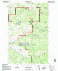
1992 Map of Cooke Mountain
USGS Topo · Published 1996About this map
Cooke Mountain and Belcher Mountain anchor this high-elevation landscape within the Colville National Forest. The 1992 survey documents a region defined by its water management and resource extraction, notably the North Fork Sanpoil River and South Fork Sanpoil River. Human intervention is evident through the presence of a Diversion Dam and an associated Diversion Ditch near a Settling Pond, reflecting the infrastructure required for local industry or water diversion in Ferry County.
Find a feature on this map
21 named features on this map. Tap any name to fly to it.
Don’t see what you’re looking for? This feature index may not catch every label — zoom into the map to look around manually.
Map Details
Editions of this 1992 Cooke Mountain Map
This is the sole edition of this map. No revisions or reprints were ever made.
Other maps of this area

1904 · Republic
USGS Topo · 1:125,000

1936 · Marcus
USGS Topo · 1:96,000

1942 · Marcus
USGS Topo · 1:125,000

1948 · Curlew
USGS Topo · 1:62,500

1948 · Republic
USGS Topo · 1:62,500

1948 · Sherman Peak
USGS Topo · 1:62,500

1948 · Togo Mountain
USGS Topo · 1:62,500

1951 · Togo Mountain
USGS Topo · 1:62,500

1951 · Sherman Peak
USGS Topo · 1:62,500

1951 · Curlew
USGS Topo · 1:62,500