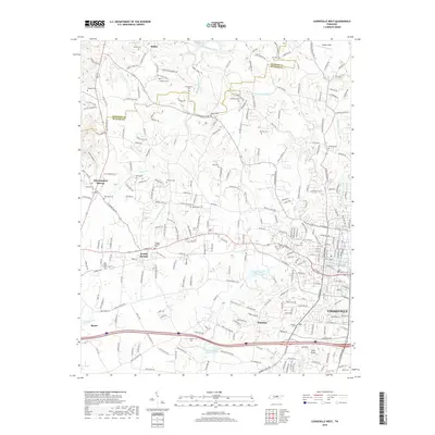
2019 Map of Cookeville West
USGS Topo · Published 2019About this map
Bloomington Springs and the surrounding highlands of the Eastern Highland Rim are meticulously detailed in this recent record of western Putnam County. The landscape is defined by the complex drainage of the Blackburn Fork and its tributaries, such as W Blackburn Fork and E Blackburn Fork, which carve through the terrain north of the Interstate 40 corridor. The map reveals a dense network of local history, preserved through numerous family-named burial grounds like Mayberry Cem, Quarles Cem, and Wilmoth Cem. The transition from rural homesteads to the expanding outskirts of Cookeville is evident, particularly around Cane Creek Lake and the prominent elevation of Pilot Knob. Significant historic thoroughfares like the Gainesboro Grade continue to orient the rural landscape, connecting long-standing communities like Shiloh, Double Springs, and Holladay.
Find a feature on this map
259 named features on this map. Tap any name to fly to it.
Don’t see what you’re looking for? This feature index may not catch every label — zoom into the map to look around manually.
Map Details
Editions of this 2019 Cookeville West Map
This is the sole edition of this map. No revisions or reprints were ever made.
Other maps of this area

1897 · Standingstone
USGS Topo · 1:125,000

1898 · Standingstone
USGS Topo · 1:125,000

1925 · Gainesboro
USGS Topo · 1:62,500

1929 · Gainesboro
USGS Topo · 1:62,500

1943 · Cookeville
USGS Topo · 1:100,000

1944 · Cookeville
USGS Topo · 1:100,000

1951 · Windle
USGS Topo · 1:24,000

1953 · Cookeville East
USGS Topo · 1:24,000

1953 · Cookeville West
USGS Topo · 1:24,000
1955 · Windle
USGS Topo · 1:24,000