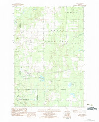
1983 Map of Cooks
USGS Topo · Published 1984About this map
The small settlement of Cooks serves as the primary hub in this portion of the Upper Peninsula, situated along the Soo Line railroad during the early 1980s. This region is defined by the intersection of the Hiawatha National Forest and Thompson State Forest, illustrating a landscape managed for timber and conservation. Genealogists will find notable value in the location of three distinct burial grounds: the Cooks Cem, Township Cem, and the Seventh Day Adventist Cem. The terrain is characterized by a dense network of glacial lakes and wetlands, including Ninemile Lake, Michaud Lake, and Tighe Lake. To the south, the Little Fishdam River meanders toward the shore of Lake Superior, while the Garden Grade Road provides a clear trace of the area's logging and transport history.
Find a feature on this map
26 named features on this map. Tap any name to fly to it.
Don’t see what you’re looking for? This feature index may not catch every label — zoom into the map to look around manually.
Map Details
Editions of this 1983 Cooks Map
This is the sole edition of this map. No revisions or reprints were ever made.
Other maps of this area

1931 · Cooks NE
USGS Topo · 1:31,680

1931 · Steuben SE
USGS Topo · 1:31,680

1931 · Steuben SW
USGS Topo · 1:31,680

1931 · Cooks NW
USGS Topo · 1:31,680

1932 · Skeels Lake SE
USGS Topo · 1:31,680

1932 · Garden SE
USGS Topo · 1:31,680

1932 · Garden NE
USGS Topo · 1:31,680

1954 · Escanaba
USGS Topo · 1:250,000

1957 · Escanaba
USGS Topo · 1:250,000

1958 · Escanaba
USGS Topo · 1:250,000