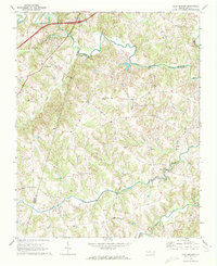
1969 Map of Cool Springs
USGS Topo · Published 1972About this map
South Yadkin River flows eastward across the northern boundary of this Piedmont landscape, forming a natural divide where Iredell, Davie, and Rowan counties meet. The late 1960s terrain is characterized by a dense network of small tributaries including Fifth Creek, Little Creek, and Hunting Creek, which feed into the larger river system. This area is defined by its scattered rural communities and deep-rooted religious landmarks, with many congregations situated at high points between the creek basins.
Find a feature on this map
23 named features on this map. Tap any name to fly to it.
Don’t see what you’re looking for? This feature index may not catch every label — zoom into the map to look around manually.
Map Details
Editions of this 1969 Cool Springs Map
2 editions found
Other maps of this area

1893 · Statesville
USGS Topo · 1:125,000

1953 · Charlotte
USGS Topo · 1:250,000

1954 · Charlotte
USGS Topo · 1:250,000

1960 · Charlotte
USGS Topo · 1:250,000

1962 · Charlotte
USGS Topo · 1:250,000

1969 · Cooleemee
USGS Topo · 1:24,000

1969 · Cool Springs
USGS Topo · 1:24,000

1969 · Shepherds
USGS Topo · 1:24,000
1969 · Harmony
USGS Topo · 1:24,000
1969 · Mocksville
USGS Topo · 1:24,000