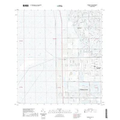
2021 Map of Cooper City SW
USGS Topo · Published 2021About this map
The Everglades dominates the western half of this Florida landscape, defined by its characteristic wetlands and the straight line of the Conservation Levee - US27 Trl. To the east, the rapid development of Broward County is visible through the structured suburban grids and planned communities of Weston and Pembroke Pines. The South New River Canal provides a major east-west hydrological boundary, separating the denser northern developments from the more sprawling estates and equestrian-focused properties in Southwest Ranches and Rolling Oaks. Notable local landmarks include the Menorah Gardens and the northern reaches of Bishops Tpke. This map illustrates the sharp contrast between the conserved wilderness of the glades and the expanding residential infrastructure of the late twentieth and early twenty-first centuries.
Find a feature on this map
35 named features on this map. Tap any name to fly to it.
Don’t see what you’re looking for? This feature index may not catch every label — zoom into the map to look around manually.
Map Details
Editions of this 2021 Cooper City SW Map
This is the sole edition of this map. No revisions or reprints were ever made.
Other maps of this area

1949 · Opalocka
USGS Topo · 1:24,000

1956 · Miami
USGS Topo · 1:250,000

1956 · West Palm Beach
USGS Topo · 1:250,000

1957 · West Palm Beach
USGS Topo · 1:250,000

1958 · West Palm Beach
USGS Topo · 1:250,000

1958 · Miami
USGS Topo · 1:250,000

1962 · Opa-locka
USGS Topo · 1:24,000

1963 · Andytown
USGS Topo · 1:24,000

1963 · Pennsuco
USGS Topo · 1:24,000

1963 · Cooper City SW
USGS Topo · 1:24,000