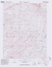
2001 Map of Cooper Peak
USGS Topo · Published 2004About this map
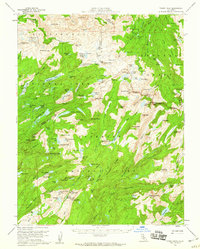
The high Sierra Nevada landscape of the Emigrant Wilderness is defined here by a dense network of glacial basins and granite peaks. Notable landmarks like Cooper Peak, Castle Rock, and Burst Rock punctuate the high-elevation terrain, overlooking the headwaters of the South Fork Stanislaus River and the West Fork Cherry Creek. This 2001 revision highlights a complex hydrography of alpine lakes, including Jewelry Lake, Gem Lake, and Leighton Lake, alongside several expansive meadows such as Coyote Meadows and Piute Meadow. The presence of the Meadow Dam and various wilderness boundaries indicates the intersection of water resource management and conservation efforts within the Stanislaus National Forest. For researchers, the map provides a clear look at the traditional transit corridors through the mountains, such as Eagle Pass and the rugged drainage of Louse Canyon.
Find a feature on this map
55 named features on this map. Tap any name to fly to it.
Don’t see what you’re looking for? This feature index may not catch every label — zoom into the map to look around manually.
Map Details
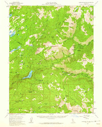
Editions of this 2001 Cooper Peak Map
2 editions found

Other maps of this area

1896 · Dardanelles
USGS Topo · 1:125,000

1898 · Dardanelles
USGS Topo · 1:125,000

1948 · Walker Lake
USGS Topo · 1:250,000
1956 · Dardanelles Cone
USGS Topo · 1:62,500
1956 · Pinecrest
USGS Topo · 1:62,500
1956 · Sonora Pass
USGS Topo · 1:62,500
1956 · Tower Peak
USGS Topo · 1:62,500

1957 · Walker Lake
USGS Topo · 1:250,000

1962 · Walker Lake
USGS Topo · 1:250,000

1964 · Walker Lake
USGS Topo · 1:250,000