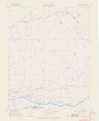
1968 Map of Cooperstown
USGS Topo · Published 1971About this map
The Tuolumne River corridor defines the southern landscape of this Central Valley survey, where massive deposits of Dredge Tailings line the riverbanks near Turlock Lake. This era shows a complex hydraulic infrastructure, with the Modesto Main Canal, Upper Main Canal, and Waterford Lower Main Canal cutting through the terrain to support local agriculture. The Sierra RR travels east toward the foothills, passing through small settlements like Warnerville and Cooperstown. Local history is anchored by the Roberts Ferry Sch and recreational areas such as Turlock Lake State Park, while industrial activity is evidenced by scattered claypits, a Quarry, and several Prospect locations. Family-named infrastructure like Barnett Road and Willms indicates the persistent ranching and landowning heritage of the region.
Find a feature on this map
42 named features on this map. Tap any name to fly to it.
Don’t see what you’re looking for? This feature index may not catch every label — zoom into the map to look around manually.
Map Details
Editions of this 1968 Cooperstown Map
3 editions found
Other maps of this area

1893 · Sonora
USGS Topo · 1:125,000

1896 · Sonora
USGS Topo · 1:125,000

1897 · Sonora
USGS Topo · 1:125,000

1898 · Sonora
USGS Topo · 1:125,000

1913 · Dickenson
USGS Topo · 1:31,680

1915 · Paulsell
USGS Topo · 1:31,680

1915 · La Grange
USGS Topo · 1:24,000

1916 · Three Tree Flat
USGS Topo · 1:31,680

1916 · Montpellier
USGS Topo · 1:31,680

1916 · Cooperstown
USGS Topo · 1:31,680