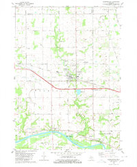
1980 Map of Coopersville
USGS Topo · Published 1980About this map
The Grand River serves as the dominant geographic anchor for this portion of Ottawa County, providing a historical focal point for the riverside communities of Eastmanville and Lamont. These small settlements, positioned along the northern bank, stand in contrast to the more industrial development concentrated around the Grand Trunk Western railroad corridor to the north. In Coopersville, the landscape shows a transition from agricultural roots to modern infrastructure, evidenced by the central high school, the Church of the Savior, and the nearby Pilot Country Landing Strip.
Find a feature on this map
41 named features on this map. Tap any name to fly to it.
Don’t see what you’re looking for? This feature index may not catch every label — zoom into the map to look around manually.
Map Details
Editions of this 1980 Coopersville Map
This is the sole edition of this map. No revisions or reprints were ever made.
Other maps of this area

1929 · Holland
USGS Topo · 1:62,500

1930 · Muskegon
USGS Topo · 1:62,500

1932 · Holland
USGS Topo · 1:62,500

1936 · Muskegon
USGS Topo · 1:62,500

1945 · Ravenna
USGS Topo · 1:62,500

1954 · Milwaukee
USGS Topo · 1:250,000

1954 · Midland
USGS Topo · 1:250,000

1958 · Midland
USGS Topo · 1:250,000

1958 · Milwaukee
USGS Topo · 1:250,000

1958 · Allendale
USGS Topo · 1:24,000
Featured Places
- Coopersville, MI
- Wright Township, MI
- Ravenna Township, MI
- Chester Township, MI
- Allendale Charter Township, MI