Loading...
Loading map...1936 Map of Muskegon
USGS Topo · Published 1936About this map
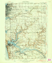
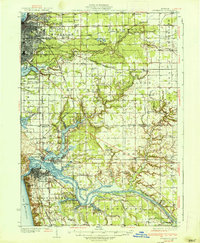
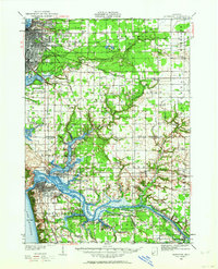
Grand Haven and Muskegon anchor this 1930s survey, illustrating the complex intersection of Great Lakes maritime activity and industrial rail networks. The lower Grand River is a labyrinth of secondary waterways, including Pottawattomie Bayou, Lloyds Bayou, and Dermo Bayou, which speak to the area's timber-era history and subsequent development as a shipping hub. The Pere Marquette and Grand Trunk Railway lace through the townships of Fruitport and Norton, connecting manufacturing centers with the wider Michigan landscape.
Find a feature on this map
98 named features on this map. Tap any name to fly to it.
Don’t see what you’re looking for? This feature index may not catch every label — zoom into the map to look around manually.
Map Details
Date Portrayed1936
Date Published1936
PublisherU.S. Geological Survey
Map TypeTopographic
Scale1:62,500
Physical Dimensions16.4 x 20 inches
Editions of this 1936 Muskegon Map
2 editions found
Historical Maps of Muskegon Through Time
3 maps found

Featured Locations
Source Details
SourceU.S. Geological Survey
CopyrightPublic Domain