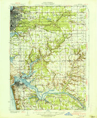
1936 Map of Muskegon
USGS Topo · Published 1936About this map
Grand Haven and the mouth of the Grand River serve as the focal point for this mid-1930s coastal survey, illustrating the complex hydrology where the river meets Lake Michigan. The area is defined by a dense network of inland waters, including Spring Lake, Mona Lake, and numerous named bayous such as Pottawattomie Bayou and Stearns Bayou. The maritime and industrial character of the shoreline is evident, with the Pere Marquette railroad lines threading through Ferrysburg and the lakefront.
Find a feature on this map
93 named features on this map. Tap any name to fly to it.
Don’t see what you’re looking for? This feature index may not catch every label — zoom into the map to look around manually.
Map Details
Editions of this 1936 Muskegon Map
2 editions found
Other maps of this area

1929 · Montague
USGS Topo · 1:48,000

1929 · Holland
USGS Topo · 1:62,500

1930 · Lake Harbor
USGS Topo · 1:48,000

1930 · Muskegon
USGS Topo · 1:62,500

1932 · Holland
USGS Topo · 1:62,500

1936 · Muskegon
USGS Topo · 1:62,500

1936 · Lake Harbor
USGS Topo · 1:62,500

1945 · Ravenna
USGS Topo · 1:62,500

1954 · Milwaukee
USGS Topo · 1:250,000

1954 · Midland
USGS Topo · 1:250,000