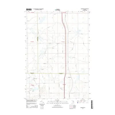
2014 Map of Cooperton
USGS Topo · Published 2014About this map
Cooperton sits at a geographic crossroads where Old US-27 cuts through the junction of Missaukee, Roscommon, and Clare Counties. The landscape is defined by the winding course of the Muskegon River, which crosses the western portion of the quadrangle and is spanned by the Jonesville Bridge. This region in northern Michigan is a patchwork of wetlands and water bodies, including Grass Lake, Wraco Lodge Lake, and the small Rice Pond near Wilson Grove. The hydrological network is further shaped by several tributaries, notably Wolf Cr, Bear Cr, and Town Line Cr. A grid of rural roads and trails, such as Hosco Rd and Osceola Trl, provides access to these timbered and marshy environments, reflecting the area's character as a site for outdoor recreation and rural residency.
Find a feature on this map
64 named features on this map. Tap any name to fly to it.
Don’t see what you’re looking for? This feature index may not catch every label — zoom into the map to look around manually.
Map Details
Editions of this 2014 Cooperton Map
This is the sole edition of this map. No revisions or reprints were ever made.
Other maps of this area

1954 · Traverse City
USGS Topo · 1:250,000

1956 · Houghton Lake
USGS Topo · 1:62,500

1957 · Harrison
USGS Topo · 1:62,500

1958 · Traverse City
USGS Topo · 1:250,000

1963 · Prudenville
USGS Topo · 1:24,000

1969 · Meredith NW
USGS Topo · 1:24,000

1969 · Meredith SW
USGS Topo · 1:24,000

1983 · Moddersville
USGS Topo · 1:25,000
1983 · Houghton Lake
USGS Topo · 1:25,000
1983 · Houghton Lake
USGS Topo · 1:100,000