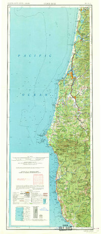
1962 Map of Coos Bay
USGS Topo · Published 1962About this map
The Oregon coastline is defined here by its complex interaction between deep-water estuaries and the rugged timberlands of the Siuslaw National Forest and Siskiyou National Forest. By the late 1950s, the maritime and industrial identity of Coos Bay was firmly established, with the adjacent municipalities of North Bend and Empire serving as critical hubs for the region's shipping and timber exports. The reliance on water-level transport is evident in the path of the Southern Pacific railroad and the winding course of the Coquille River near Coquille.
Find a feature on this map
43 named features on this map. Tap any name to fly to it.
Don’t see what you’re looking for? This feature index may not catch every label — zoom into the map to look around manually.
Map Details
Editions of this 1962 Coos Bay Map
2 editions found

Other maps of this area

1896 · Coos Bay
USGS Topo · 1:125,000

1898 · Coos Bay
USGS Topo · 1:125,000

1899 · Port Orford
USGS Topo · 1:125,000

1900 · Coos Bay
USGS Topo · 1:125,000

1903 · Port Orford
USGS Topo · 1:125,000

1917 · Kerby
USGS Topo · 1:125,000

1918 · Kerby
USGS Topo · 1:125,000

1918 · Mapleton
USGS Topo · 1:48,000

1919 · Earl
USGS Topo · 1:48,000

1920 · Siltcoos Lake
USGS Topo · 1:62,500