
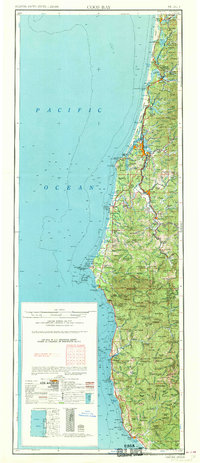
1962 Map of Coos Bay
USGS Topo · Published 1962About this map
North Bend and the surrounding Coos Bay harbor serve as the industrial anchor for this stretch of the Oregon coast during the late 1950s. The map illustrates a landscape defined by its timber and maritime economies, with the Southern Pacific RR winding through the coastal mountains to reach mill towns like Coquille and Myrtle Point. To the north, the terrain is characterized by a series of significant coastal lakes including Siltcoos Lake and Tenmile Lake, which give way to the sprawling timberlands of the Siuslaw National Forest.
Find a feature on this map
54 named features on this map. Tap any name to fly to it.
Don’t see what you’re looking for? This feature index may not catch every label — zoom into the map to look around manually.
Map Details
Editions of this 1962 Coos Bay Map
2 editions found
Other maps of this area

1896 · Coos Bay
USGS Topo · 1:125,000

1898 · Coos Bay
USGS Topo · 1:125,000

1899 · Port Orford
USGS Topo · 1:125,000

1900 · Coos Bay
USGS Topo · 1:125,000

1903 · Port Orford
USGS Topo · 1:125,000

1917 · Kerby
USGS Topo · 1:125,000

1918 · Kerby
USGS Topo · 1:125,000

1918 · Mapleton
USGS Topo · 1:48,000

1919 · Earl
USGS Topo · 1:48,000

1920 · Siltcoos Lake
USGS Topo · 1:62,500