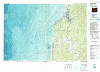
1993 Map of Coos Bay
USGS Topo · Published 1993About this map
The deep estuaries of Coos Bay and the winding Coquille River define the coastal landscape of southwest Oregon in the early 1990s. This topographic-bathymetric survey provides a detailed look at the maritime and industrial infrastructure supporting the region, from the North Bend Municipal Airport to the Southern Pacific rail lines serving the timber and shipping hubs. The intricate network of tidal flats and waterways, including Catching Slough and Isthmus Slough, illustrates the complex geography that shaped early settlements like Bunker Hill, Empire, and Southport.
Find a feature on this map
89 named features on this map. Tap any name to fly to it.
Don’t see what you’re looking for? This feature index may not catch every label — zoom into the map to look around manually.
Map Details
Editions of this 1993 Coos Bay Map
This is the sole edition of this map. No revisions or reprints were ever made.
Other maps of this area

1896 · Coos Bay
USGS Topo · 1:125,000

1898 · Coos Bay
USGS Topo · 1:125,000

1899 · Port Orford
USGS Topo · 1:125,000

1900 · Coos Bay
USGS Topo · 1:125,000

1903 · Port Orford
USGS Topo · 1:125,000

1923 · Reedsport
USGS Topo · 1:62,500

1928 · Sitkum
USGS Topo · 1:125,000

1942 · Reedsport
USGS Topo · 1:62,500

1942 · Empire
USGS Topo · 1:62,500

1942 · Coquille
USGS Topo · 1:62,500