
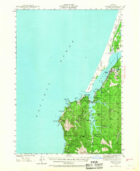
1942 Map of Empire
USGS Topo · Published 1958About this map
Coos Bay dominates this coastal landscape, where the interplay between industrial development and rugged Pacific shorelines is captured during the early 1940s. The settlement of Empire serves as a primary hub, supported by a Pulp Mill and proximity to the North Bend City Bdy. Further south, the landscape shifts toward a network of family-operated holdings such as Sengstacken Ranch, Metcalf Ranch, and Miller Ranch. These sites, alongside local education centers like Beach View Sch and South Slough Sch, provide a detailed view of the rural community structure before modern expansion.
Find a feature on this map
61 named features on this map. Tap any name to fly to it.
Don’t see what you’re looking for? This feature index may not catch every label — zoom into the map to look around manually.
Map Details
Editions of this 1942 Empire Map
2 editions found
Other maps of this area

1896 · Coos Bay
USGS Topo · 1:125,000

1898 · Coos Bay
USGS Topo · 1:125,000

1900 · Coos Bay
USGS Topo · 1:125,000

1923 · Reedsport
USGS Topo · 1:62,500

1942 · Reedsport
USGS Topo · 1:62,500

1942 · Coquille
USGS Topo · 1:62,500

1942 · Coos Bay
USGS Topo · 1:62,500

1943 · Bandon
USGS Topo · 1:62,500

1944 · Empire
USGS Topo · 1:62,500

1944 · Bandon
USGS Topo · 1:62,500