
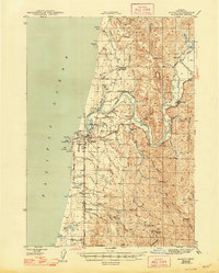
1944 Map of Bandon
USGS Topo · Published 1944About this map
The Coquille River serves as the central artery for this mid-century coastal survey, winding through a landscape of timber, tide-flats, and burgeoning industry. Near the river's mouth, the town of Bandon sits protected by the Coquille River LH, while the interior sections are marked by the presence of significant mining operations. The northern hills around Seven Devils Creek show the Seven Devils Mine and the Eagle Mine (Abandoned), pointing to the region's extraction history. Local education and community nodes are prominent along the drainages, including the Parkersburg Sch and Twomile Sch. The mapping of the Oregon Coast Highway illustrates the era's focus on connectivity between the river settlements like Prosper and Riverton and the rugged shoreline at Face Rock and Grave Pt.
Find a feature on this map
60 named features on this map. Tap any name to fly to it.
Don’t see what you’re looking for? This feature index may not catch every label — zoom into the map to look around manually.
Map Details
Editions of this 1944 Bandon Map
2 editions found
Other maps of this area

1896 · Coos Bay
USGS Topo · 1:125,000

1898 · Coos Bay
USGS Topo · 1:125,000

1899 · Port Orford
USGS Topo · 1:125,000

1900 · Coos Bay
USGS Topo · 1:125,000

1903 · Port Orford
USGS Topo · 1:125,000

1942 · Empire
USGS Topo · 1:62,500

1942 · Coquille
USGS Topo · 1:62,500

1942 · Coos Bay
USGS Topo · 1:62,500

1943 · Bandon
USGS Topo · 1:62,500

1944 · Empire
USGS Topo · 1:62,500